















GAGAN-Guided A320 Landing: How the SBAS Landing System (SLS) CAT I Works

- An IndiGo A320 at Udaipur completed India’s first commercial aircraft approach and landing using the SBAS Landing System, or SLS, with GAGAN satellite navigation.
- GAGAN, India’s GPS Aided Geo Augmented Navigation system, improves GPS accuracy and integrity for aircraft navigation and approach guidance.
- SLS can provide Instrument Landing System-like Category I guidance at suitable airports, though Category II and III low-visibility landings still require higher-category systems.

Photo: Airbus
On 27 June 2026, an IndiGo A320 carried out an approach and landing at Udaipur using the Space-Based Augmentation System (SBAS). It was the first time that an Indian commercial aircraft approached and landed at an Indian airport using indigenous GAGAN (GPS Aided Geo Augmented Navigation), the Indian SBAS.
GAGAN has been in use for en-route navigation for a long time, but for landing, it was used for the first time. Use of SBAS for landing began with the EGNOS Safety-of-Life (SoL) Service becoming available to support the implementation of Approach Procedures with Vertical Guidance (APV) down to Localiser Performance with Vertical Guidance (LPV) minima.
In 2015, Airbus introduced its SBAS Landing System (SLS) on its widebody A350, enabling pilots to perform precision CAT I-like approaches and landings in reduced visibility conditions using Satellite-Based Augmentation System (SBAS) lateral and Vertical positioning. The facility has since been extended to the A320 family.
SBAS CAT I History
The performance of basic SBAS (including GAGAN) is limited by ionospheric disturbances, which do not permit it to be used for landing. Precision approach and landing demands a very high level of accuracy and integrity of the guidance. SBAS relies on a grid to estimate upper-atmosphere (ionospheric) delays.
Particularly in equatorial regions (like India) during severe solar activity, electron density shifts rapidly, and this invalidates standard models, leading to tremendous errors and increased integrity risks. In addition, basic SBAS cannot independently support vertical guidance requirements for precision landing.
To enhance the accuracy of SBAS performance and improve the integrity of the information provided, Airbus Industries and EGNOS developed an SBAS-based system to support APV down to the LPV minimum. On Sept 29, 2015, the LPV-200 service was declared operational and was added within the Safety-of-Life (SoL) services, enabling the implementation of LPV approaches down to a Decision Height (DH) of 200ft.
The system is also known as SBAS CAT I and is now becoming more attractive than the conventional ILS CAT I under some circumstances.
Principles of Operation
To understand the principle of operation of SLS CAT I, we have to first understand why SBAS cannot be used for the final phase of Approach and Landing. Let us consider the Indian SBAS, i.e. GAGAN. It has 15 reference ground stations located at Ahmedabad, Bengaluru, Bhubaneswar, Delhi, Dibrugarh, Gaya, Guwahati, Jaisalmer, Jammu, Kolkata, Nagpur, Porbandar, Port Blair and Trivandrum.
These stations are required to serve the whole of Indian subcontinent, which makes it very difficult (because of very large separation between these reference stations) for it to provide the level of accuracy and integrity that is required for aircraft landing operation at every point within the coverage of GAGAN. To make it fit for approach and landing, the following additional infrastructure (Fig – 1) is created at the landing airport.
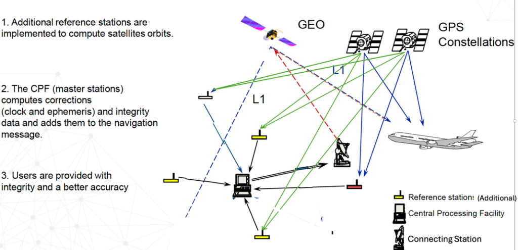
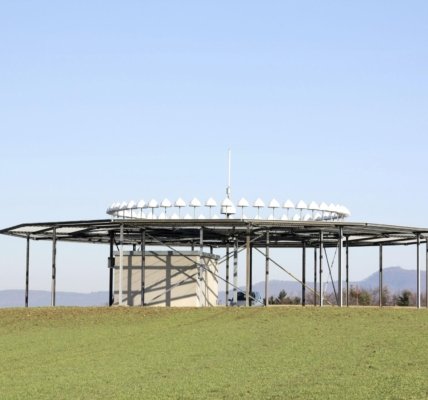
Normally, 2 to 4 additional local Reference Stations (in addition to basic SBAS reference stations) at pre-surveyed locations are added at around 5km from the landing threshold. Signal received at these stations is almost identical as that received by aircraft because of short distance.
Applicable corrections (like clock, ephemeris, ionospheric) to the signals received from GNSS (GPS) satellites in the local Reference Stations are sent to the Central Processing Facility. Consolidated corrections to the signals received from the visible GNSS (GPS) satellites are converted to a navigation message and are broadcast to the aircraft through a GEO Stationary Satellite.
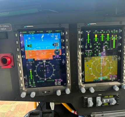
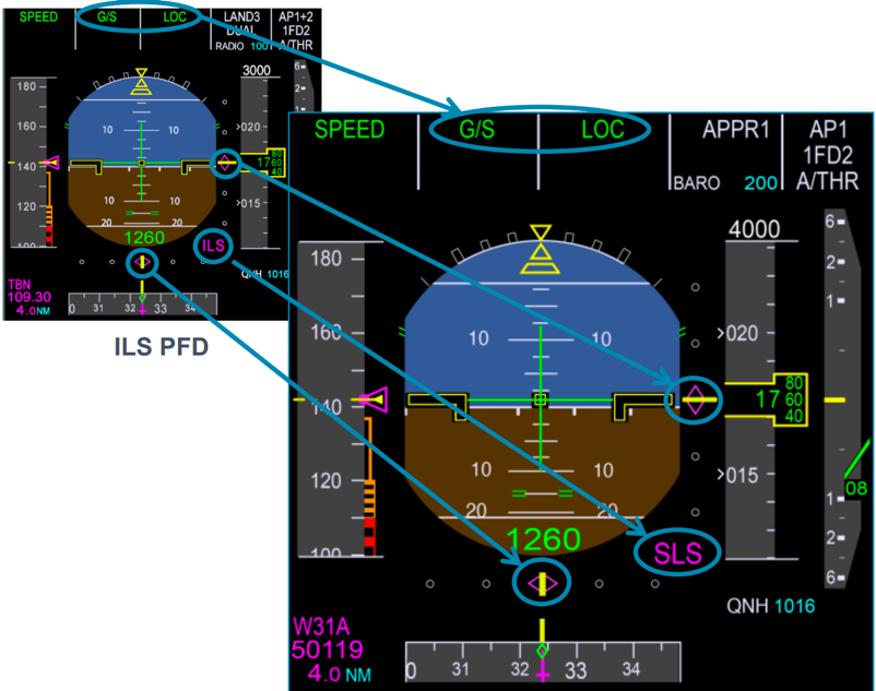
This message, along with the GPS signals and the SBAS navigation message from Geo-stationary satellite are analysed in the special Airbus Multi Modal Receiver (MMR) on board the aircraft and the output is fed to the cockpit Primary Flight Display (PFD) (Fig – 2). The display for SLS CAT I is kept exactly the same as that for ILS to reduce stress on the pilot.
Facilitating Precision Approach
Because of varying atmospheric conditions (like ionospheric, tropospheric, etc.), approaches based on SBAS are generally not stable. Resultant regular variations in the path lengths do not permit the provision of a stable approach path (in spite of some correction provided by SBAS).
In SLS, because of the correction available from local reference stations (in addition to the basic SBAS), the accuracy and stability of the approach path improve significantly. Correction derived from the SBAS signals received at the SLS reference stations and conveyed through the GEO satellite is applied on a real-time basis and thus corrects and stabilises the path.
Vertical guidance for the aircraft is generally provided by barometric altitude observations, which depend significantly on temperature calibration. In conventional LNAV/VNAV as well as ‘non-precision approaches’, altitude observation is affected by variations in barometric readings. In SLS, RNP APCH to LPV has the advantage of not relying on conventional barometric altitude; vertical guidance is no longer barometric but geometric, so the approach path remains unaffected by meteorological conditions.
Integrity Requirements
ICAO SARPs for integrity requirements for different phases of flight are provided in Table – 1:
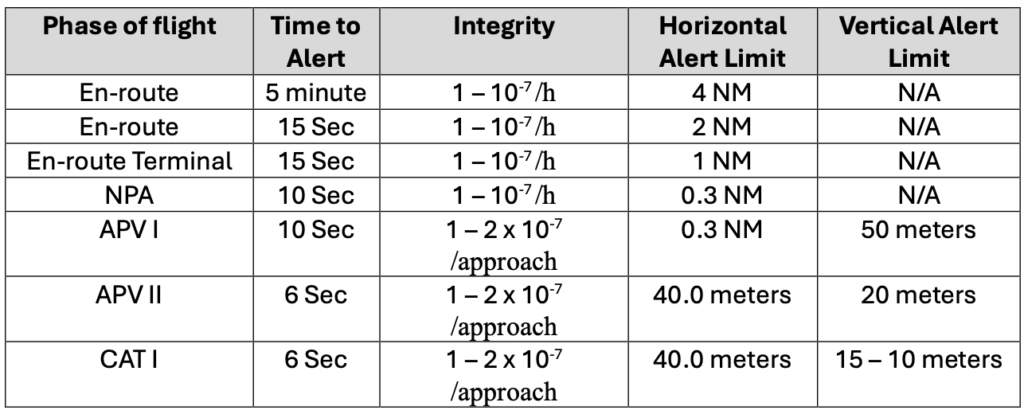
As has been explained, the accuracy and stability of approaches in terms of horizontal and vertical guidance lead to the possibility of getting tighter alert limits. Also, since the time for the correction data derivation process and transmission via a GEO satellite reduces significantly, it becomes possible for SLS to meet the ‘Time to Alert’ requirement.
Path length between SLS ground sensors and the SLS control unit is much smaller (5km) compared to the distance between the SBAS reference stations and the Indian Mission Control Centre (INMCC) (thousands of kilometres).
While standard SBAS can take up to 6 seconds to detect an anomaly and warn the pilot, SLS CAT I can sense and raise an alarm within 1 to 2 seconds (because of precise monitoring at the additional SLS reference stations).
Conclusion
SLS CAT 1 benefits civil air operations in following ways;
- It can be beneficial, particularly for those secondary airports, where a low level of operation does not justify the installation of a conventional Instrument Landing System (ILS), requiring large expenditure for acquiring and maintaining it.
- Convention ILS uses very big beam forming areas in the airports and denies its usage for any other operational and commercial purposes.
- Since additional SLS reference stations are located in the vicinity or within the airport (where obstructions are controlled in any way), the effect of multi path because of reflection is very much reduced.
- Because of terrain conditions, sometimes it becomes impossible to use a conventional ILS at some airports. SLS CAT I can be used at these airports to provide ILS CAT I-like performance and support operations even in adverse weather conditions.
- Because the cockpit display looks the same as that used for conventional ILS, it reduces training requirements for pilots.
- The integrity and accuracy of an SLS CAT I are much superior to those of SBAS because it incorporates a local ground-based augmentation system to calculate and verify integrity bounds, rather than relying strictly on the conventional wide-range SBAS broadcast.
Since in India SBAS is already available (GAGAN), it will be very beneficial to consider installing SLS CAT I facilities, particularly in North Indian airports where operations suffer drastically because of low visibility conditions. As of now, SBAS can only support CAT I level of precision; for CAT II and CAT III operations, conventional ILS will still be required.
Also Read: Gogo’s Multi-Orbit Connectivity Strategy for Business Aviation in India
Dr. SK Saraswati – He joined Civil Aviation Department in 1972 through Engineering Services Examination and has an extensive experience in planning, procurement, installation, commissioning, maintenance, calibration, as instructor of Communication, Navigation, Surveillance and ATM Automation. He also served as Airport Director (Bangalore, Hyderabad) and Regional Executive Director. He served ICAO and after retirement was Consultant to Tata Advanced Systems Ltd.